Wednesday, July 8, 2009

The Swiss National Park

http://upload.wikimedia.org/wikipedia/commons/6/6e/Swiss_National_Park_002.JPG

The Swiss National Park (German: Schweizerischer Nationalpark; French: Parc National Suisse; Italian: Parco Nazionale Svizzero; Romansh: Parc Naziunal Svizzer) is located in the east of Switzerland between Zernez, S-chanf, Scuol and the Fuorn Pass in the Engadin valley. As of 2009, it is the only National Park in Switzerland, though there are plans to create more. It has an area of 174.2 km² and is the largest protected area of the country. It was founded on 1 August 1914, the national holiday of Switzerland. It was one of the earliest national parks in Europe. In the park, one is not allowed to leave the road, make fire or sleep outside the Chamanna Cluozza, the mountain hut located in the park. It is also forbidden to disturb the animals or the plants, or to take home anything found in the park. Dogs are not allowed, not even on a leash.

A visitor centre is located in Zernez. The official website is here.

The Graubünden or Grisons Canton

Graubünden or Grisons (German: Graubünden, [ɡʁaʊˈbʏndən] ; Swiss German: Graubünda; Italian: Grigioni [ɡɾiˈdʒoni]; Romansh: Grischun [ɡɾiˈʒun]) is the largest and easternmost canton of Switzerland adjoining Italy, Austria and Liechtenstein . The name Graubünden translates as "Grey Leagues," referring to the canton's origin in three local alliances, the League of God's House, the Grey League, and the League of Ten Jurisdictions.

http://upload.wikimedia.org/wikipedia/commons/8/8f/Swiss_Canton_Map_GR.png

The area of the canton is 7,105.2 square kilometers (2,743.3 sq mi). Only about a third of this is commonly regarded as productive land. Forests cover about a fifth of the total area. The canton is almost entirely mountainous, comprising the highlands of the Rhine and Inn river valleys. Many of its scenic areas are part of the Swiss National Park or the Ela Nature Park. Additionally, the some of the mountains were formed as part of the thrust fault that was declared a geologic UNESCO world heritage site, under the name Swiss Tectonic Arena Sardona, in 2008.

There are many significant elevations in the Grison Alps, including the Tödi at 3,614 meters (11,857 ft) and the highest peak Piz Bernina at 4,049 meters (13,284 ft). Many of the mountain ranges feature extensive glaciers, such as at the Adula, the Albula, the Silvretta, the Bernina, the Bregaglia and the Rätikon ranges. The mountain ranges in the central area are very deep, some of which are considered the deepest valleys in Europe. These valleys were originally settled by the Raetians (Rhaeti).

http://upload.wikimedia.org/wikipedia/commons/1/1b/PizBernina3.jpg

The canton borders on Liechtenstein to the north, Austria to the north and the east, Italy to the south and southeast, and the cantons of St. Gallen to the northwest, Canton of Glarus, Uri to the west, and Ticino to the southwest. The capital city is Chur. The world-famous resorts of Davos, Klosters and St. Moritz are located in the canton, as are the towns of Arosa, Flims, Laax, Pontresina, Scuol and Sils.

Monday, March 16, 2009

Mount Pilatus

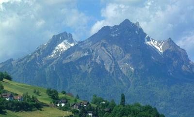
Mount Pilatus from Burgenstock Lake Lucerne
Mount Pilatus overlooks Lucerne and the surrounding lakes and towns. Enjoy a slow cog-wheel train ride up the steep hill side. Watch as the grass gradually becomes snow covered as you reach higher elevations. You will hear the sounds of cow bells in the distance. The cows are used to living in this extreme and are not afraid of the heights. When you arrive at the top you will notice it is much colder than when you boarded the train. Step out and look at a rare sight. Lucerne and it's surrounding communities in all their glory from 2000 meters above. There is much to see on the observation deck at the top. Look for locals performing with real alp-horns. Keep traveling to the very peaks of the observation area, and you will find yourself out of breath from the lack of oxygen and from the amazing sight in front of you. You can grab something to eat while you are on top of the mountain. Enjoy the ride down on a cable car ride. This ride is truly like nothing else you will ever experience.

Mount Pilatus From the PeakThere are many ways to enjoy this trip. You can find transportation to Alpnachstad and start a hike for the more adventurous tourists. You could also start in Kreins a smaller town near Lucerne and take a four-person aerial cable car to Frakmuntegg and make the switch into a larger cable car that will take you to the summit. You can also reach the top by way of cogwheel train. For most visitors, the best choice is a Golden Roundtrip excursion, which combines a boat or rail trip to Alpnachstad, a 30-minute cogwheel train ascent, a 5-minute descent by aerial cable car to Frakmuntegg, a half-hour ride in a small cable car through the treetops to Kriens, and a 15-minute bus ride back to the Lucerne train station. The Golden round-trip will cost you 92 Swiss Francs per person which is about 61 Euro or 82 US Dollars.

Rhine River

Rhine River - Lai da Tuma Origin
Rhine (rīn) , Du. Rijn, Fr. Rhin, Ger. Rhein, Lat. Rhenus, principal river of Europe, c.820 mi (1,320 km) long. It rises in the Swiss Alps and flows generally north, passing through or bordering on Switzerland, Liechtenstein, Austria, Germany, France, and the Netherlands before emptying into the North Sea. Its important tributaries are the Aare, Neckar, Main, Moselle, and Ruhr rivers; canals link the river with the Maas, Rhône-Saône, Marne, and Danube (via the Main) valleys.

The Rhine's highest source, the Hinter Rhine, issues from the Rheinwaldhorn Glacier more than 11,000 ft (3,353 m) above sea level and joins the Vorder Rhine, flowing from Lake Tuma, to form the Rhine proper at Reichenau, S of Chur, Switzerland. From Chur the river flows N to Lake Constance and then W over the 65-ft (20-m) Rhine Falls at Schaffhausen (harnessed for hydroelectric power by the Swiss) to Basel, c.500 mi (800 km) from the North Sea.
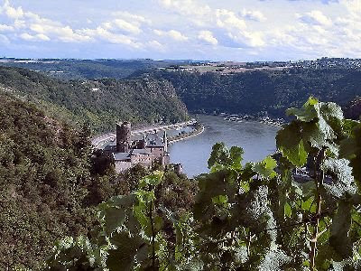
Rhine RiverAt Basel the Rhine becomes the Upper Rhine of the Germans and turns sharply N to Mainz across the broad-floored Rhine rift valley, a large graben, or down-faulted block, between the Black Forest and the Vosges Mts. Navigation here is by way of a lateral canal through France as far as Strasbourg; below Strasbourg the riverbed has been improved for navigation. Below Mainz, at Bingen, Germany, the Rhine leaves the rift valley and flows for c.80 mi (130 km) across the Rhenish Slate Mts. in a steep gorge, famous for its scenery and wines, with castles surviving from times when tolls were levied on the river's traffic, and landmarks such as the Lorelei and the Drachenfels.

Beyond Bonn the river becomes the Lower Rhine of the Germans and emerges onto the North German Plain as a broad, sluggish, and increasingly polluted river flowing on a bed of deltaic deposits left by ancestors of the modern river. Efforts to solve the pollution problem began in the late 1970s and had achieved considerable, if not complete, success by the late 1990s.

Rhine River - Swiss Grand CanyonJust below Emmerich, on the border with the Netherlands, the modern delta begins, and the Rhine breaks up into two major distributaries, the Lek and the Waal. The Lek, which becomes the Nieuwe Maas, continues W to Rotterdam and then by the canalized New Waterway enters the North Sea at Hoek van Holland (Hook of Holland). The Waal, which merges with the waters of the Maas to form the Merwede, also flows west; the Merwede and the Bergsche Maas join to form the Hollandschdiep, an arm of the North Sea, 6 mi (9.6 km) SE of Dordrecht. A third distributary, known as the Crooked Rhine, leads to Utrecht and continues west to the sea as the Old Rhine; it is linked with Amsterdam by the Amsterdam-Rhine Canal and thence by the North Sea Canal to the North Sea.

The Rhine was declared free to international navigation in 1868, and in 1919 navigation of the river between Basel and Krimpen, on the Lek, and Gorinchem, on the Waal, was placed under the authority of the Central Rhine Commission, with headquarters at Strasbourg. Navigation above Basel is controlled jointly by Switzerland and Germany.
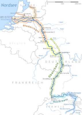
Rhine River MapThe river carries more traffic than any other waterway in the world and is navigable by oceangoing vessels as far as Mannheim, Germany, by river barges to Basel, Switzerland, and by pleasure craft and sightseeing boats on navigable stretches as far as Rheinfelden, Switzerland. Coal, coke, grain, timber, and iron ore are the principal cargoes carried on the river. Rotterdam is the chief outlet to the North Sea, and Duisburg, the outlet for the Ruhr industrial region, is the leading river port. The Rhine-Main-Danube canal, completed in 1992, now allows barge traffic between the North Sea and the Black Sea.
Thursday, February 5, 2009

Lake Lucerne (Vierwaldstättersee): The "Lake of the Four Forest Cantons"

Lake Lucerne (Vierwaldstättersee): The "Lake of the Four Forest Cantons"

Lake Lucerne (Vierwaldstättersee)

Lake Lucerne (German: Vierwaldstättersee, lit. "Lake of the Four Forest Cantons") is a lake in central Switzerland, the fourth largest in the country.

The lake is a complicated shape, with bends and arms reaching from the city of Lucerne into the mountains. It has a total area of 114 km² (44 sq mi), an elevation of 434 m (1,424 ft), and a maximum depth of 214 m (702 ft). Its volume is 11.8 km³. Much of the shoreline rises steeply into mountains up to 1,500 m above the lake, resulting in many picturesque views including those of Mount Rigi and Mount Pilatus.

It borders on the three original Swiss cantons of Uri, Schwyz, and Unterwalden (which today is divided into the Cantons of Obwalden and Nidwalden), as well as the canton of Lucerne, thus the name. Many of the oldest communities of Switzerland are along the shore, including Küssnacht, Weggis, Vitznau, Gersau, Brunnen, Altdorf, Buochs, and Treib. In addition, the meadow of the Rütli, traditional site of the founding of the Swiss Confederation, is on the southeast shore of the lake.

Lake Lucerne at Weggis

The Reuss River enters the lake at Flüelen (in the canton of Uri, the part called Urnersee) and exits at Lucerne. The lake also receives the Muota (at Brunnen) Engelberger Aa (at Buochs), the Sarner Aa (at Stansstad).

It is possible to circumnavigate the lake by road, though the route is slow, twisted, and goes through tunnels part of the way. Dozens of steamers ply between the different towns on the lake. It is a popular tourist destination, both for native Swiss and foreigners, and there are many hotels and resorts along the shores.

The level of the lake is maintained by a pioneering needle dam in the Reuss River in Lucerne, just upstream from the Spreuerbrücke.

The lake's surface is the lowest point of the cantons of Uri, Obwalden and Nidwalden.

Mount Titlis: The Peak of Glacier

Mount Titlis: The Peak of Glacier

Titlis

The Titlis (3,238 m) is a mountain in the Urner Alps of Switzerland. It is located on the border between the cantons of Obwalden and Berne in Switzerland, overlooking Engelberg (Obwalden) and is famous as the site of the world's first revolving cable car. The cable car system connects Engelberg to the summit of Klein Titlis (3,028 m) through the three stages of GerschnialpTrübsee (1,796 m) and Stand (2,428 m). (1,262 m),

The last part of cable car way leads above the glacier. In Klein Titlis, it is possible to visit a glacier cave.

Titlis Peak of Glacier


The peak of the glacier near Lucerne offers a special sensation: when taking the aerial cable-car to the top, the gondolas start revolving on the 600-meter-long segment beginning in Stand and ending at the mountain station Klein Titlis located at 3,020 meters above sea level.

Titlis Rotating Cable Car

The installation of this daring project was just another technical pioneering feat in Engelberg. In 1927, the first aerial cableway in the Alps started operating. Then in 1959, Engelberg was the first town to install parallel cable-cars, and in 1989 the first revolving cable-car. the Titlis-Rotair, was approved. During the five-minute ride, the gondolas turn 360° around their axis, giving all passengers the opportunity to marvel at the panorama of the Engelberg Valley, the deep abbysses and the crevasses of the Titlis Glacier. The summit tour on the "Ice Flyer" glacier chairlift offers breathtaking views of the crevasses on the glacier at the top of the Titlis. This is followed by a visit to the glacier grotto and finally fun in the summer snow with all kinds of equipment for sliding on.

Wednesday, February 4, 2009

Rigi Mountain: The "Queen of the Mountains"

Rigi Mountain: The "Queen of the Mountains"

Rigi at the Vierwaldstädtteresee.

Rigi is a mountain in central Switzerland and part of the Swiss Alps. It's also known as the "Queen of the Mountains."

The mountain is easily accessible by public transportation. It offers many winter and summer excursions such as skiing or sledding. Hiking there is also a favorite. It can be reached from Goldau and Vitznau by the Rigi-Bahnen, a rack railway, and from Weggis by cable car.

The Rigi has been further made famous through paintings by JMW Turner, including "The Blue Rigi, Lake of Lucerne, Sunrise".

Rigi behind Lake Lauerz.

The Rigi is a quite well-known 1800m mountain in the pre-Alps, occupying a spectacular location above the Vierwaldstättersee (Lake Lucerne) and offering on a clear day splendid views south to the Alps as well as north back to the area around Zurich. The Rigi featured in a book by Mark Twain and in a number of paintings by J.M.W. Turner. The Rigi, while not the highest, is one of the best known mountains in Switzerland and is named "Queen of the mountains". Its proximity to Zurich and Lucerne make it a magnet for tourists visiting the area.

Rigi consists of many peaks. Vitznauerstock V (also called Gersauerstock), Kulm K, Hochfluh H.

One may choose to hike to the top or climb or combine hiking with a climb up one of the several rock routes in the 4+ to 6 range.

Swiss Railways offer a special round-trip excursion, the “Rigi-Rundfahrt”, covering multiple segments by train, cog-railway, gondola (optional) and lake steamer.

If you had a toy cablecar as a kid, chances are it was a Rigi Seilbahn replica manufactured nearby.

Wednesday, January 21, 2009

Lake Geneva: It's always been the place

Lake Geneva: It's always been the place

Lake Geneva or Lake Léman (French: Lac Léman, Léman, Lac de Genève) is the second largest freshwater lake in Central Europe in terms of surface area (after Lake Balaton). 60% of it comes under the jurisdiction of Switzerland (cantons of Vaud, Geneva, and Valais), and 40% under France (Haute-Savoie).

The crescent-shaped lake, formed by a withdrawing glacier, narrows around Yvoire on the southern shore, the lake can thus be divided into the "Grand Lac" (Large Lake) to the east and the "Petit Lac" (Small Lake) to the west.

It lies on the course of the Rhône River. The river has its source at the Rhone Glacier near the Grimsel Pass to the east of the lake and flows down through the Canton of Valais, entering the lake between Villeneuve and St. Gingolph, before flowing slowly towards its egress at Geneva. Other tributaries are La Dranse, L'Aubonne, La Morges, Venoge, and Veveyse.

The Lake Geneva has an alpine character. The Chablais Alps border its southern shore, the western Bernese Alps lie over its eastern side. The high summits of Grand Combin and Mont Blanc are even visible from a few places.

By the 1960s, the lake had ceased being a transport artery for commercial and construction materials. In the late 1960s pollution made it dangerous to swim at some beaches of the lake; indeed, tourists taking a ride in the local submarine had near zero visibility (it was eventually sold). By the 1980s, intense environmental pollution (eutrophication) had almost wiped out all the fish. Today, pollution levels have been dramatically cut back, and it is again considered safe to swim in the lake. Major leisure activities practiced include sailing, wind surfing, boating (including water skiing and wakeboarding), rowing, scuba diving and bathing.

As an interesting historical and scientific footnote, in 1827, Lake Geneva was the site for the first measurement of the speed of sound in (fresh) water. French mathematician Jacques Charles François Sturm and Swiss Physicist Daniel Collodon used two moored boats, separated by a measured distance, as the transmit and receive platforms for the sounds of exploding gunpowder. The loud airborne sound coupled into the lake, establishing a loud underwater sound that could be measured at a distance. The flash of the exploding gunpowder provided the visual starting cue for the timepiece, and the underwater explosion sound striking a bell provided the finish cue.

The shore between Nyon and Lausanne is called La Côte because it is "flatter". Between Lausanne and Vevey it is called Lavaux and is famous for its hilly vineyards.

The lake's surface is the lowest point of the cantons of Valais and Vaud.

Compagnie Générale de Navigation sur le lac Léman (CGN) operates boats on the lake.

 
Tour to Switzerland Copyright © 2009 Blogger Template Designed by Bie Blogger Template