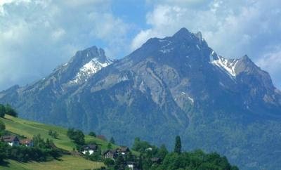
Mount Pilatus overlooks Lucerne and the surrounding lakes and towns. Enjoy a slow cog-wheel train ride up the steep hill side. Watch as the grass gradually becomes snow covered as you reach higher elevations. You will hear the sounds of cow bells in the distance. The cows are used to living in this extreme and are not afraid of the heights. When you arrive at the top you will notice it is much colder than when you boarded the train. Step out and look at a rare sight. Lucerne and it's surrounding communities in all their glory from 2000 meters above. There is much to see on the observation deck at the top. Look for locals performing with real alp-horns. Keep traveling to the very peaks of the observation area, and you will find yourself out of breath from the lack of oxygen and from the amazing sight in front of you. You can grab something to eat while you are on top of the mountain. Enjoy the ride down on a cable car ride. This ride is truly like nothing else you will ever experience.
 There are many ways to enjoy this trip. You can find transportation to Alpnachstad and start a hike for the more adventurous tourists. You could also start in Kreins a smaller town near Lucerne and take a four-person aerial cable car to Frakmuntegg and make the switch into a larger cable car that will take you to the summit. You can also reach the top by way of cogwheel train. For most visitors, the best choice is a Golden Roundtrip excursion, which combines a boat or rail trip to Alpnachstad, a 30-minute cogwheel train ascent, a 5-minute descent by aerial cable car to Frakmuntegg, a half-hour ride in a small cable car through the treetops to Kriens, and a 15-minute bus ride back to the Lucerne train station. The Golden round-trip will cost you 92 Swiss Francs per person which is about 61 Euro or 82 US Dollars.
 There are many ways to enjoy this trip. You can find transportation to Alpnachstad and start a hike for the more adventurous tourists. You could also start in Kreins a smaller town near Lucerne and take a four-person aerial cable car to Frakmuntegg and make the switch into a larger cable car that will take you to the summit. You can also reach the top by way of cogwheel train. For most visitors, the best choice is a Golden Roundtrip excursion, which combines a boat or rail trip to Alpnachstad, a 30-minute cogwheel train ascent, a 5-minute descent by aerial cable car to Frakmuntegg, a half-hour ride in a small cable car through the treetops to Kriens, and a 15-minute bus ride back to the Lucerne train station. The Golden round-trip will cost you 92 Swiss Francs per person which is about 61 Euro or 82 US Dollars.


