Rhine (rīn) , Du. Rijn, Fr. Rhin, Ger. Rhein, Lat. Rhenus, principal river of Europe, c.820 mi (1,320 km) long. It rises in the Swiss Alps and flows generally north, passing through or bordering on Switzerland, Liechtenstein, Austria, Germany, France, and the Netherlands before emptying into the North Sea. Its important tributaries are the Aare, Neckar, Main, Moselle, and Ruhr rivers; canals link the river with the Maas, Rhône-Saône, Marne, and Danube (via the Main) valleys.
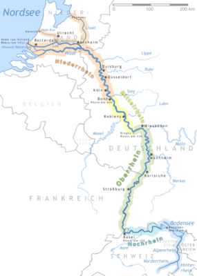
The Rhine's highest source, the Hinter Rhine, issues from the Rheinwaldhorn Glacier more than 11,000 ft (3,353 m) above sea level and joins the Vorder Rhine, flowing from Lake Tuma, to form the Rhine proper at Reichenau, S of Chur, Switzerland. From Chur the river flows N to Lake Constance and then W over the 65-ft (20-m) Rhine Falls at Schaffhausen (harnessed for hydroelectric power by the Swiss) to Basel, c.500 mi (800 km) from the North Sea.
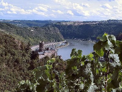
 At Basel the Rhine becomes the Upper Rhine of the Germans and turns sharply N to Mainz across the broad-floored Rhine rift valley, a large graben, or down-faulted block, between the Black Forest and the Vosges Mts. Navigation here is by way of a lateral canal through France as far as Strasbourg; below Strasbourg the riverbed has been improved for navigation. Below Mainz, at Bingen, Germany, the Rhine leaves the rift valley and flows for c.80 mi (130 km) across the Rhenish Slate Mts. in a steep gorge, famous for its scenery and wines, with castles surviving from times when tolls were levied on the river's traffic, and landmarks such as the Lorelei and the Drachenfels.
Beyond Bonn the river becomes the Lower Rhine of the Germans and emerges onto the North German Plain as a broad, sluggish, and increasingly polluted river flowing on a bed of deltaic deposits left by ancestors of the modern river. Efforts to solve the pollution problem began in the late 1970s and had achieved considerable, if not complete, success by the late 1990s.
 Just below Emmerich, on the border with the Netherlands, the modern delta begins, and the Rhine breaks up into two major distributaries, the Lek and the Waal. The Lek, which becomes the Nieuwe Maas, continues W to Rotterdam and then by the canalized New Waterway enters the North Sea at Hoek van Holland (Hook of Holland). The Waal, which merges with the waters of the Maas to form the Merwede, also flows west; the Merwede and the Bergsche Maas join to form the Hollandschdiep, an arm of the North Sea, 6 mi (9.6 km) SE of Dordrecht. A third distributary, known as the Crooked Rhine, leads to Utrecht and continues west to the sea as the Old Rhine; it is linked with Amsterdam by the Amsterdam-Rhine Canal and thence by the North Sea Canal to the North Sea.
The Rhine was declared free to international navigation in 1868, and in 1919 navigation of the river between Basel and Krimpen, on the Lek, and Gorinchem, on the Waal, was placed under the authority of the Central Rhine Commission, with headquarters at Strasbourg. Navigation above Basel is controlled jointly by Switzerland and Germany.
 The river carries more traffic than any other waterway in the world and is navigable by oceangoing vessels as far as Mannheim, Germany, by river barges to Basel, Switzerland, and by pleasure craft and sightseeing boats on navigable stretches as far as Rheinfelden, Switzerland. Coal, coke, grain, timber, and iron ore are the principal cargoes carried on the river. Rotterdam is the chief outlet to the North Sea, and Duisburg, the outlet for the Ruhr industrial region, is the leading river port. The Rhine-Main-Danube canal, completed in 1992, now allows barge traffic between the North Sea and the Black Sea.
The Rhine's highest source, the Hinter Rhine, issues from the Rheinwaldhorn Glacier more than 11,000 ft (3,353 m) above sea level and joins the Vorder Rhine, flowing from Lake Tuma, to form the Rhine proper at Reichenau, S of Chur, Switzerland. From Chur the river flows N to Lake Constance and then W over the 65-ft (20-m) Rhine Falls at Schaffhausen (harnessed for hydroelectric power by the Swiss) to Basel, c.500 mi (800 km) from the North Sea.
 At Basel the Rhine becomes the Upper Rhine of the Germans and turns sharply N to Mainz across the broad-floored Rhine rift valley, a large graben, or down-faulted block, between the Black Forest and the Vosges Mts. Navigation here is by way of a lateral canal through France as far as Strasbourg; below Strasbourg the riverbed has been improved for navigation. Below Mainz, at Bingen, Germany, the Rhine leaves the rift valley and flows for c.80 mi (130 km) across the Rhenish Slate Mts. in a steep gorge, famous for its scenery and wines, with castles surviving from times when tolls were levied on the river's traffic, and landmarks such as the Lorelei and the Drachenfels.
Beyond Bonn the river becomes the Lower Rhine of the Germans and emerges onto the North German Plain as a broad, sluggish, and increasingly polluted river flowing on a bed of deltaic deposits left by ancestors of the modern river. Efforts to solve the pollution problem began in the late 1970s and had achieved considerable, if not complete, success by the late 1990s.
 Just below Emmerich, on the border with the Netherlands, the modern delta begins, and the Rhine breaks up into two major distributaries, the Lek and the Waal. The Lek, which becomes the Nieuwe Maas, continues W to Rotterdam and then by the canalized New Waterway enters the North Sea at Hoek van Holland (Hook of Holland). The Waal, which merges with the waters of the Maas to form the Merwede, also flows west; the Merwede and the Bergsche Maas join to form the Hollandschdiep, an arm of the North Sea, 6 mi (9.6 km) SE of Dordrecht. A third distributary, known as the Crooked Rhine, leads to Utrecht and continues west to the sea as the Old Rhine; it is linked with Amsterdam by the Amsterdam-Rhine Canal and thence by the North Sea Canal to the North Sea.
The Rhine was declared free to international navigation in 1868, and in 1919 navigation of the river between Basel and Krimpen, on the Lek, and Gorinchem, on the Waal, was placed under the authority of the Central Rhine Commission, with headquarters at Strasbourg. Navigation above Basel is controlled jointly by Switzerland and Germany.
 The river carries more traffic than any other waterway in the world and is navigable by oceangoing vessels as far as Mannheim, Germany, by river barges to Basel, Switzerland, and by pleasure craft and sightseeing boats on navigable stretches as far as Rheinfelden, Switzerland. Coal, coke, grain, timber, and iron ore are the principal cargoes carried on the river. Rotterdam is the chief outlet to the North Sea, and Duisburg, the outlet for the Ruhr industrial region, is the leading river port. The Rhine-Main-Danube canal, completed in 1992, now allows barge traffic between the North Sea and the Black Sea.